Maps · the brochure · the archives
Where the record actually is.
Historic maps, aerial photographs, recorded tract maps, the Lindenwood sales brochure and the architects’ archives — what exists, who holds it, and what you may do with it.
Library of Congress
Two years after 19 Irving
From our own copy
Historic maps
Public domain, and free to use.
Atherton falls on the United States Geological Survey’s Palo Alto quadrangle. Its historical topographic maps are public domain; USGS asks only for a credit. The 1941 and 1943 editions predate the 1945 sale of the Lindenwood home sites. The 1953 and 1961 editions, at the larger 1:24,000 scale, come after 19 Irving was built.
- USGS topoView — historical topographic mapsSearch “Palo Alto, CA.” Editions 1897, 1899, 1941, 1943, 1948 (1:62,500); 1953, 1961 (1:24,000).
- Official map of San Mateo County, D. Bromfield, 1894Library of Congress. Lot lines and landowners’ names, the Flood holdings among them. Free to reuse.
- Sanborn fire insurance maps, Atherton, 1928Library of Congress. Thirteen sheets. Catalogued, not digitised.
- Sanborn, Atherton, 1928 updated to 1943Fourteen sheets. Not digitised; the later corrections may carry their own copyright.
- Sanborn, Menlo Park, 1888–1925Seven editions from 1888; this link is 1925. Check whether a sheet reaches the Flood estate.
Credit lines: “U.S. Geological Survey”; “Library of Congress, Geography and Map Division.”
From the air
Aerial photographs since 1937.
USGS EarthExplorer holds single-frame aerial photographs from April 1937 onward, free to download at up to 1,000 dpi and described as public domain — though some frames were flown by other agencies, so check each. UC Santa Barbara’s collection is larger, but many of its flights were commercial and still need the copyright holder’s permission for any commercial use.
- USGS EarthExplorer — Aerial Photo Single FramesPublic domain. Cite DOI 10.5066/F7610XKM.
- UCSB Library Geospatial Collection — San Mateo County indexNo fee to view; clear each flight before republishing.
On the ground
Recorded maps and zoning.
San Mateo County’s property-maps portal holds recorded subdivision maps, searchable by volume and page. We have not found Lindenwood’s recorded tract map online, or the name of the tract’s developer; the county recorder is where to look. The Town of Atherton publishes its zoning map, and the zoning rules are on our costs page.
- San Mateo County property maps (recorded maps)Assessor and recorded subdivision maps, by volume and page.
- San Mateo County public planning viewerParcels and layers. Its zoning covers unincorporated land only.
- Town of Atherton — Zoning MapThe town’s own map page.
The brochure
Four designs, one identified.
Eichler Homes sold Lindenwood with a brochure of three- and four-bedroom designs by Anshen & Allen, at $42,500 to $49,500. Eichler Network dates it 1953; its own timeline files the same prices under 1951.
Only one of the four designs can be identified: Plan 37, drawn in August 1951, marketed at $47,500, built around an eleven-foot-square open court — and built at 73 Hawthorne Drive. The names, sizes and plans of the other three are not in any source we could find.
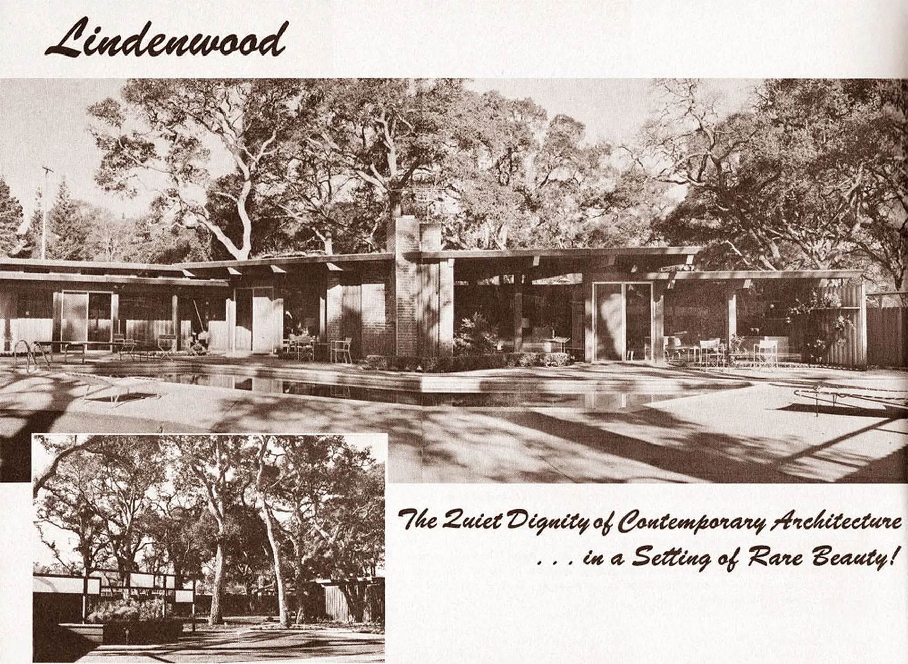
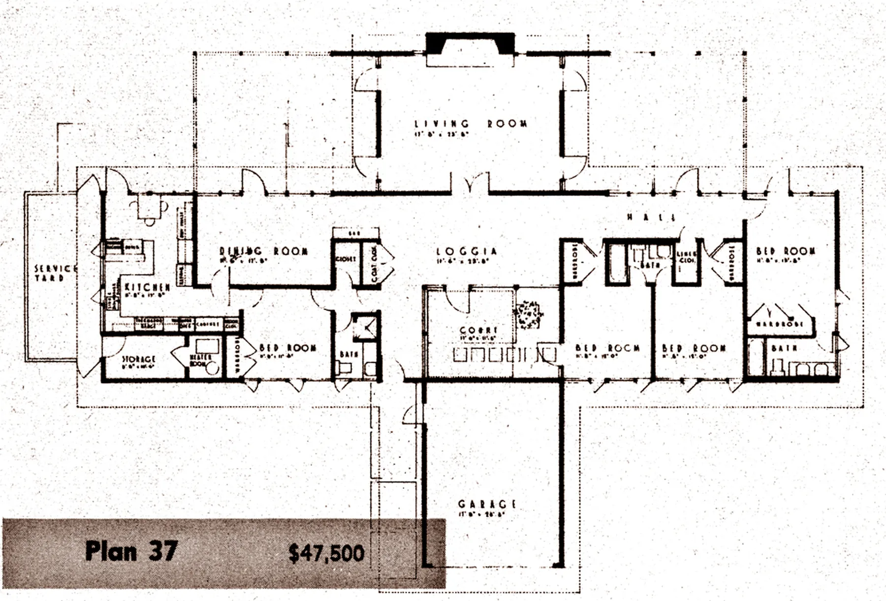
The other three designs are still unaccounted for. If you hold any other page of this brochure, or a different Eichler Homes leaflet for Atherton, we would like to add it. The Anshen & Allen Collection at UC Berkeley, whose 2022 addition holds material from the firm’s Eichler projects, is the other place worth looking.
The architects’ archives
Where the plans are.
The drawings for most Eichlers survive in three collections. All are open to researchers; publishing anything from them needs the archive’s permission.
- Anshen & Allen Collection, UC Berkeley EDA1917–2007, 38.5 linear feet. Includes Steve Allen’s 1970 “Project Family Tree.”
- Oakland & Imada Collection, UC Berkeley EDA1942–2002, 57 linear feet, mostly Eichler project records.
- Eichler site plans, virtual collectionTract site plans from the Oakland & Imada records, online.
- A. Quincy Jones papers, UCLA (LSC.1692)1942–1979, 33.5 linear feet. Jones & Emmons, including the Willie Mays house.
- An Easy Way to Find Eichler Home PlansEichler Network’s how-to for the archives.
What we left off
And why.
The David Rumsey Map Collection is licensed for non-commercial use only, so we do not reproduce from it on a brokerage site. A 1937 “Atherton Heights” sales map circulates in the rare-map trade; it is not Lindenwood. And the California State Archives’ “Alfred Eichler Collection” belongs to a different man — Alfred Eichler, the state architect.
Questions we get asked
The ones that come up.
- Where can I find the original plans for my Eichler?
- Start with the architect. Anshen & Allen and Claude Oakland’s papers are at UC Berkeley’s Environmental Design Archives; Jones & Emmons’s are at UCLA. The Town of Atherton’s building department holds the permit history by address.
- Can I see the Lindenwood brochure?
- Two pages of it are on this page: the Lindenwood cover and the Plan 37 floor plan, from our own copy. No reproduction of it has been published online before, and the other three designs are still missing.
- Can I use these maps on my own website?
- USGS maps and the Library of Congress’s digitised maps are free to reuse with a credit. Aerial photographs and archive drawings depend on who made them; check each.
What we can do for you
Things worth asking us for.
Help us finish the record
If you hold something from 1951 to 1960, we would like to see it.
The 1953 Lindenwood brochure, a plan leaflet, a construction photograph, a letter from Eichler Homes — the documentary record for Atherton is thin, and a scan of what is in your drawer makes it better for every owner in town. We will credit you, or not, exactly as you prefer.
Talk to us
If it is in your drawer.
A brochure, a plan leaflet, a construction photograph, a recorded map with pencil notes on it — if you have something from Atherton’s Eichler years, a scan makes the record better for every owner in town.
Where to go next
Read these three.
The rest of the story